
GALLOWAY LANDS MASTERPLAN
conservation design showcase
Client
Handshake Holdings Ltd.
Project Type
Master planned community, conservation design and development
Location
Fernie, British Columbia, Canada
Status
Application December 2022, Rezoning July 2023, Final Approvals 2024
Scope
Research, conservation report, terrain modelling, masterplan concepts, analysis, planning advice
Haworth Development Consulting (land use planning), Cascade Environmental Resource Group, Bunt & Associates (transportation)
Collaborators
A Vision for Sustainable Development
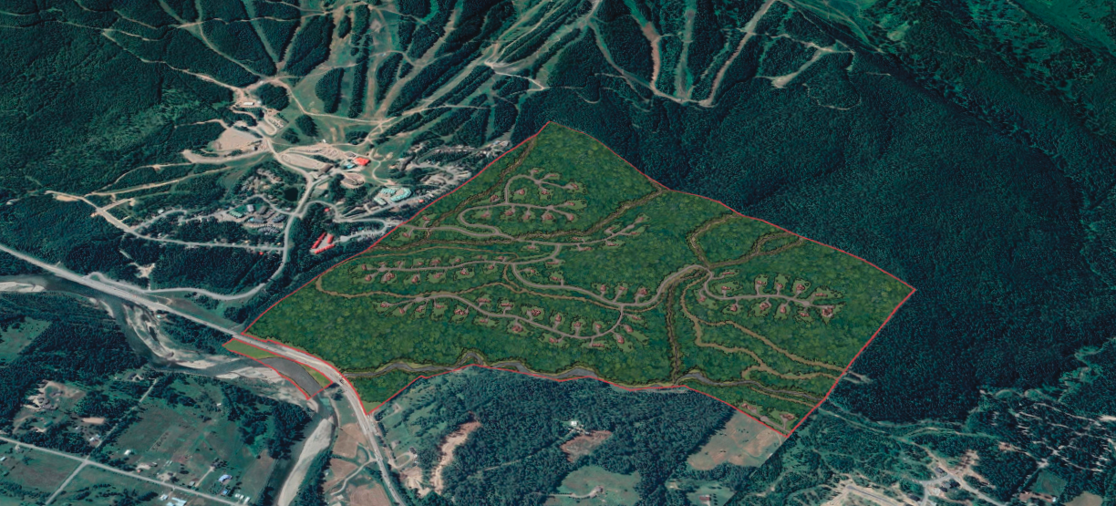
Located in the beautiful Elk Valley of the Canadian Rockies, the Galloway Lands are a former private forestry block located between Fernie Alpine Resort and the Town of Fernie within the Regional District of East Kootenay (RDEK).
This rugged 457-acre (185 Ha) site was acquired in 2024 by local resident Reto Barrington and investors “committed to building a sustainable neighbourhood that will add to the beauty and livability of our amazing region.” A multi-disciplinary team was assembled to create a long-term master plan “to protect the environment and set this development apart” to the benefit of the local economy and community.
Guiding Principles: Conservation Design
The starting point was the RDEK Official Community Plan, which sought to accommodate growth while protecting the area’s natural environment and rural character. This encouraged a ‘conservation design’ approach, popularized by the book Rural by Design.
A Collaborative Approach to Planning
Working with lead consultant Richard Haworth, EDG Principal Doug Leighton was asked to apply conservation design principles to the site and generate alternative development concepts. Doug also prepared a report describing conservation design, highlighting international best practices, and outlining its benefits for public information.
Mapping Conservation and Development
EDG developed a 3D digital terrain model to help map primary and secondary conservation areas, especially the sensitive Lizard Creek riparian area. Alternative road and trail alignments, homesite locations, and development configurations were then modelled within the residual development area. The results helped inform engagement with community and environmental groups, Ktunaxa First Nation, and the Town of Fernie and led to a series of refined plans.
A Balance of Preservation and Thoughtful Growth
The final masterplan would see 58% of the site (262 acres or 106 Ha) set aside for conservation and recreation, including Nordic ski, mountain bike, and multi-use trails. The balance of the site will accommodate 105 carefully placed individual homesites, with development quality ensured by architectural and landscape design controls.
A Model for the Future
Approved in 2024, the Galloway Lands will become a model conservation community that meets client objectives and aspirations. A collaborative design process resulted in a masterplan that will achieve the vision and benefit the local community, environment, and economy.


